Large Molybdenum Project in Sonora, Mexico
In February 2015, Starcore International Mining, through its acquisition of Creston Moly Corp, acquired a 100% interest in the El Creston Property. The El Creston Property hosts a 5.5 km long x up to 1.5km wide trend of hydrothermal alteration in which several zones of molybdenum +/- copper +/- silver mineralization occur. At the El Creston Main/Red Hill Zone a significant resource of molybdenum and copper has been outlined. In addition, there are five other zones, Alejandra, A-37, Red Hill West, Red Hill Deep and the West Copper with potential to host significant resources of molybdenum and/or copper.

Location, Topography, Vegetation and Access
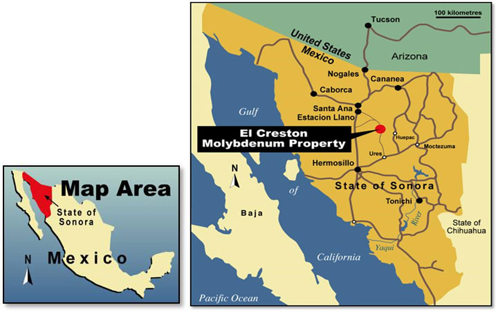
The Creston Property is centered 95 kilometers northeast of Hermosillo, north central Sonora State, Mexico. Access to the property from Hermosillo is by 145 km of paved highway and all season gravel roads. Travel time is approximately 2 hours. The 230KV power grid is 42 km to the west.
The Property occurs within the Sonoran Desert along the western foothills of the Sierra Madre Occidental Mountain Range. The eastern portion of the property overlies the San Miguel River Valley. Local elevations range from 650 metres at the valley floor to in excess of 1100 metres at some of the higher mountain peaks. Vegetation consists primarily of cactus and scrub timber.
The Creston property is located within the Basin and Range Province. The Province, extending from northern Mexico to southwestern United States hosts several porphyry copper and/or molybdenum mines and deposit including Creston that are related to a Laramide (~90-40 Ma) magmatic-orogenic event.
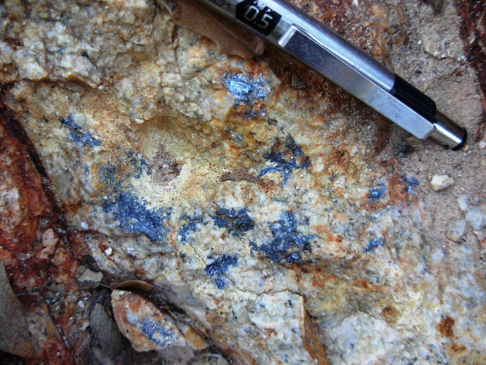
Mapping and Astar Imaging of the Creston Property has outlined a 5.5 km x up to 1.5 km wide, east-west, trend (Creston) of hydrothermal alteration related to Laramide aged quartz monzonite intrusions. The trend is elongated east-west due to subsequent displacement by low angle faulting. Within the Creston Trend several zones of low fluorine porphyry style, molybdenum and/or copper mineralization including the El Creston Main/RedHill (Creston Deposit) occur. Most of the molybdenum mineralization within the Creston Trend is associated with potassic and phyllic (quartz-sericite) alteration, often accompanied by various degrees of silicification.
The Creston Deposit is largely underlain by foliated Proterozoic Creston Granite and Laramide granitic porphyry and hydrothermal breccia. At the deposit molybdenum +/- copper mineralization are hosted in both hydrothermal breccias and the surrounding quartz vein stockwork. In addition, a supergene copper blanket consisting largely of chalcocite has been identified occurring primarily on the west and south sides of the deposit. The alteration pattern within the deposit is complex resulting from multiple intrusions and overlapping alteration. Low-angle normal faults divide the El Creston deposit in to three main tectonic slices causing sliding towards N-NNE In profile the El Creston deposit can be imaged as a series of tectonic slices, having their root in the footwall of the Creston Fault.
Most of the work completed on the Creston property has been concentrated on the evaluation of the El Creston Main and Red Hill Zones which together make up the Creston Deposit. Overall the Creston Deposit is up to 1100 metres long x up to 1000 metres wide. The work to date includes mapping, geochemical sampling, geophysical surveying and the completion of the following:
|
DRILLING-TYPE |
AMOUNT |
LENGTH (METRES) |
|---|---|---|
|
Core |
197 HOLES |
43,012.39 |
|
Reverse Circulation |
18 HOLES |
4,995.00 |
|
TOTAL |
215 HOLES |
48,007.39 |
|
DRIFTING-YEAR |
AMOUNT |
LENGTH (METRES) |
|
1936 |
2 |
188.0 |
|
1985 |
2 |
663.1 |
|
TOTAL |
4 |
851.1 |
In 2010 SRK Consulting completed Resource Inventory calculations based on the results 28 diamond drill holes completed by AMAX between 1974 to 1978 and 109 holes drilled by Creston Moly Corp representing 36,151 metres of core. The resources are summarized below.
|
CRESTON DEPOSIT RESOURCES (2010) |
||||||
|---|---|---|---|---|---|---|
|
MEASURED RESOURCE |
||||||
|
CATEGORY |
CUT-OFF |
TONNES |
Mo |
Cu |
CONTAINED Mo |
CONTAINED Cu |
|
|
>MoEq (%) |
> CUT-OFF |
% |
% |
LBS |
LBS |
|
Measured |
0.030 |
67,600,000 |
0.068 |
0.06 |
101,600,000 |
88,400,000 |
|
|
0.035 |
62,600,000 |
0.071 |
0.06 |
98,500,000 |
84,400,000 |
|
|
0.040 |
57,800,000 |
0.075 |
0.06 |
95,100,000 |
80,200,000 |
|
|
0.045 |
53,200,000 |
0.078 |
0.06 |
91,400,000 |
76,100,000 |
|
|
0.050 |
48,900,000 |
0.081 |
0.07 |
87,500,000 |
71,700,000 |
|
INDICATED RESOURCE |
||||||
|---|---|---|---|---|---|---|
|
CATEGORY |
CUT-OFF |
TONNES |
Mo |
Cu |
CONTAINED Mo |
CONTAINED Cu |
|
|
>MoEq (%) |
> CUT-OFF |
% |
% |
LBS |
LBS |
|
Indicated |
0.030 |
204,500,000 |
0.062 |
0.05 |
277,800,000 |
247,400,000 |
|
|
0.035 |
187,900,000 |
0.065 |
0.06 |
267,800,000 |
233,400,000 |
|
|
0.040 |
171,000,000 |
0.068 |
0.06 |
255,700,000 |
219,500,000 |
|
|
0.045 |
155,600,000 |
0.071 |
0.06 |
243,100,000 |
206,000,000 |
|
|
0.050 |
140,000,000 |
0.074 |
0.06 |
228,800,000 |
190,800,000 |
|
INFERRED RESOURCE |
||||||
|---|---|---|---|---|---|---|
|
CATEGORY |
CUT-OFF |
TONNES |
Mo |
Cu |
CONTAINED Mo |
CONTAINED Cu |
|
|
>MoEq (%) |
> CUT-OFF |
% |
% |
LBS |
LBS |
|
Inferred |
0.030 |
21,700,000 |
0.045 |
0.05 |
21,400,000 |
23,400,000 |
|
|
0.035 |
17,300,000 |
0.050 |
0.05 |
19,000,000 |
18,200,000 |
|
|
0.040 |
13,600,000 |
0.055 |
0.05 |
16,400,000 |
14,900,000 |
|
|
0.045 |
10,600,000 |
0.060 |
0.05 |
14,000,000 |
11,700,000 |
|
|
0.050 |
8,700,000 |
0.064 |
0.05 |
12,300,000 |
9,700,000 |
Source: Report Entitled “El Creston Moly Property, Sonora, Mexico, NI43-101 Resource Update”, December 2010, Page 108, Prepared by SRK Consultants for Creston Moly Corp.[full corporate name], a wholly owned subsidiary of Starcore International Mines Ltd. The Resource Update was released in Creston News Release #20-10 dated October 26, 2010. The report detailing the Resources is dated December 10, 2010 and was filed on Sedar December 10, 2010.
Note: SRK Consultants is a reputable consulting firm and we consider their work on resource estimates reliable. Metal prices have changed since their report was done and moly equivalent cut-off grades would be affected.
|
Mineral Resources that are not Mineral Reserves do not have demonstrated economic viability. An Inferred Mineral Resource is that part of Mineral Resource for which quantity and grade or quality are estimated on the basis of limited geological evidence and sampling. Geological evidence is sufficient to imply but not verify geological and grade of quality continuity. An Indicated Mineral Resource is that part of a Mineral Resource for which quantity, grade or quality, densities, shape and physical characteristics are estimated with sufficient confidence to allow the application of Modifying Factors in sufficient confidence to allow the application of Modifying Factors in sufficient detail to support mine planning and evaluation of the economic viability of the deposit. A Measured Mineral Resource is that part of a Mineral Resource for which quantity, grade or quality, densities, shape and physical characteristics are estimated with confidence to allow the application of Modifying Factors to support detailed mine planning and final evaluation of the economic viability of the deposit. |
According to SRK “The molybdenum and copper Mineral Resources at Creston were modelled and estimated by
- Evaluating the drill and assay data statistically, interpreting geology and structures on cross sections, analyzing the modelled mineralization geostatistically to establish estimation parameters, and estimating grades into a three-dimensional block model. Total molybdenum (in sulphides) and Total copper were modelled and estimated independently. All modeling of the Creston resources was performed using Gemcom Surpac® mining software.”
Mineral reserves can only be estimated based on the results of an economic evaluation as part of a preliminary feasibility study or feasibility study. As such, no mineral reserves have been estimate by SRK as part of the present assignment. There is no certainty that all or any part of the Mineral Resources will be converted into a Mineral Reserve. In order to complete valid classification of El Creston property Mineral Resource, the data and estimate was considered for:
- Data confidence and QA/QC;
- Data spacing (drillhole and assay);
- Deposit geological model;
- Metallurgical testing and analysis;
- Previous classification.
SRK completed the classification in a similar fashion as MDA had in the past. The El Creston Mineral Resources were classified by SRK based on the distance from a given block to the closest four composites. Blocks which are within 25m of four valid assay composites were classified as Measured. Blocks within 100m of 4 valid composites from at least two drill holes were classed as Indicated. All other estimated blocks were considered Inferred. The distance based classification was then re-interpreted for data continuity and spatial outliers in order to re-classify selected volumes where appropriate to add further validity to the final classification.
The bulk of the deposit has been classified as Indicated with a subset of the data meeting Measured classification. At the margin of the drill hole data, and to a lesser extent between the Main and Red Hill zones, material has been classified as Inferred.
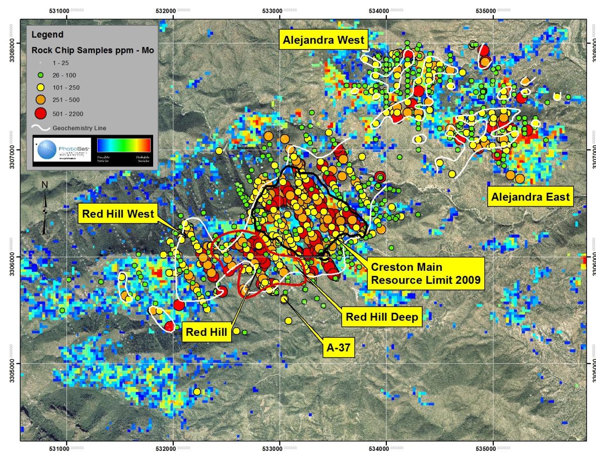
In addition to the Creston Deposit there are at least five other zones with the potential to host significant molybdenum and/or copper mineralization.
The A-37 Zone is located to the immediate south of the Creston Deposit. The zone is underlain by Proterozoic Augen Gneiss and Laramide Intrusive Breccia. Four holes have tested the zone with two of the holes intersecting near surface molybdenum values. Hole A-37, a vertical hole, included? a 94 metre intersection averaging 0.094% molybdenum commencing at a depth of 42 metres. The limited drilling does not allow for the establishment of limits of mineralization.
The Red Hill West Zone is located immediately adjacent to the western boundary of the Red Hill Zone. The zone refers to a 500 metre wide by 500 metre long zone of quartz vein stockwork, hosted by Creston Granite, in which appreciable, >100 ppm, values of molybdenum occur. The host rock is typically oxidized and variably sericitized. Chip sample results include 3 metres averaging 0.083% Mo and a 12 metre composite averaging 0.043% molybdenum. Copper values are negligible. The zone has not been drilled.
The Red Hill Deep Zone refers to a 750 metre long x up to 400 metre wide and open zone of molybdenum and copper mineralization hosted within Laramide intrusive breccia and quartz monzonite porphyry located at depth below the eastern half of the Red Hill Zone. The top of the zone is in part above the bottom of the proposed open pit. Eight drill holes have tested the zone. Results include a 241.35 metre section averaging 0.088% Mo commencing at a downhole depth of 253.15 metres.
The Copper Anomaly Zone is a 1000 metre long x up to 250 metre wide copper in rock anomaly as defined by the >0.05% Cu contour. The anomaly is underlain by mafic metamorphic complex rocks and diorite that locally have been variably fractured, argillic and chloritic altered. Within the zone, anomalous copper and silver values occur. Molybdenum values are low throughout. Chip sample results include composites of 18 and 27 metres respectfully averaging 0.210% Cu, 3.9 ppm Ag and 0.23% Cu with 4.7 ppm Ag. The Copper Anomaly Zone has not been drilled.
The Alejandra Zone is located approximately 1 k to the northeast of the Creston Deposit. The area is underlain by oxidized and variably sericite altered Proterozoic Creston Granite and Laramide porphyry granite. The >100 ppm Mo in rock chip contour has defined two areas of interest referred to as the Alejandra East and West. In both areas molybdenum values are generally modest, 100-300 ppm, with occasional spot highs. The Alejandra West is up to 500 metres wide x up to 800 metres long. Within it rock chip samples assayed up to 0.102% Mo over 3 metres. The Alejandra East Anomaly is up to 800 metres long with width variable to 700 metres. The best rock chip assayed 0.256% Mo over 3 metres. Copper values are generally low throughout. The zone has not been drilled.
The information regarding the El Creston property has been reviewed and approved by David Visagie, P.Geo a non-independent qualified person under NI 43-101 who is a consultant to Starcore International Mines Ltd. Mr. Visagie is familiar with the property as he was previously the Exploration Manager and Qualified Person for Creston Moly Corp.